Introduction
The ocean interacts closely with the atmosphere. Heat from the sun, evaporative, conduction and emission forces provide energy for ocean movement, while wind and density differences provide momentum. Changes in atmospheric pressure set up wind patterns. Predominant wind patterns are among the main forces which drive circulation. The shapes of the coastline and bathymetry differences cause changes in direction (meanders) and spin-offs (gyres) from the main current. These gyres are visible in maps of sea surface temperatures of the Gulf Stream in the North Atlantic and the California Current.
In this activity, students will explore how wind forces water movement and how land features can change this movement.
Objectives
To become familiar with the forces which produce the circulation patterns in ocean basins and to predict current patterns or eddy development with variances in bathymetry.
Materials
- Heavy duty stainless steel baking tray (10 x 16)
- Modeling clay
- Satellite images of the Gulf Stream and California Current (see Web Links)
- Bathymetric maps of the North Atlantic and California Coast (see Student Worksheet or Web Links)
- Convection Fluid Bottles, Carolina Biological Supply Item# GEO8450
- Hair Dryer or straw
- Student Worksheet (download in Lesson Resources)
Procedure
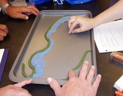
 In groups of 3-5, use clay to build a model of the bathymetry of the North Atlantic and/or US West Coast. Use the bathymetric maps in the Student Worksheet or on the web and be sure to include the continental shelf, continental slope, capes, seamounts, and other seafloor features.
- Create the shoreline in your container using the clay (no more than 1-2 inches thickness of clay on edges).
- Pour in a diluted solution of Convection Fluid to a depth which just covers the subsurface oceanic features.
- Use the hair dryer on low or blow through a straw to set up a gentle "wind" blowing from the south to start a current. Make observations on the current patterns that develop.
- Change wind direction and speed and observe any changes in the current patterns.
- Illustrate your notes on the observations, especially the patterns affected by the shoreline or around surface features (e.g. Cape Hatteras).
- When finished, return the Convection Fluid to the container. Remove clay from container and roll into ball.
- Answer the questions below, also available in the Student Worksheet.
- Optional: Check out this Global Surface Current Animation to compare your model to actual ocean current patterns.
- Did the shelf, slope or capes affect the surface current? Describe.
- Do you think the Gulf Stream might have a greater affect on weather of the southeast vs. the northeast of the USA? Explain.
- What other factors besides wind might affect the Gulf Stream current?
- Did the shelf, slope, points, or islands affect the surface current? Describe.
- Do you think the ocean currents might have a greater affect on weather south vs. north California? Explain.
- What other factors besides wind might affect the ocean current?
- Is the surface circulation of the East and West coast affected by the same parameters?
- How does West Coast Ocean circulation differ from East Coast circulation?
Web Links
- Google Maps now displays ocean features. Be sure to select "Satellite" view to see bathymetry.
- National Geophysical Data Center allows users to download sections of bathymetric maps for free.
- Global Surface Current Animation; moving image from NASA showing ocean currents compiled from satellite imagery.
- Gulf Stream and California Current still images generated by sensors measuring sea surface temperature.
