Scientists build computer models to study dead zones
Dead zone scientists use models (numerical representations of real ecosystems) to predict and explore the causes of dead zones. Scientists first draw a diagram of the ecosystem parts they want to model and then embed this ecosystem model in each cell of a large grid for the ecosystem. The example below shows the Chesapeake Bay ecosystem.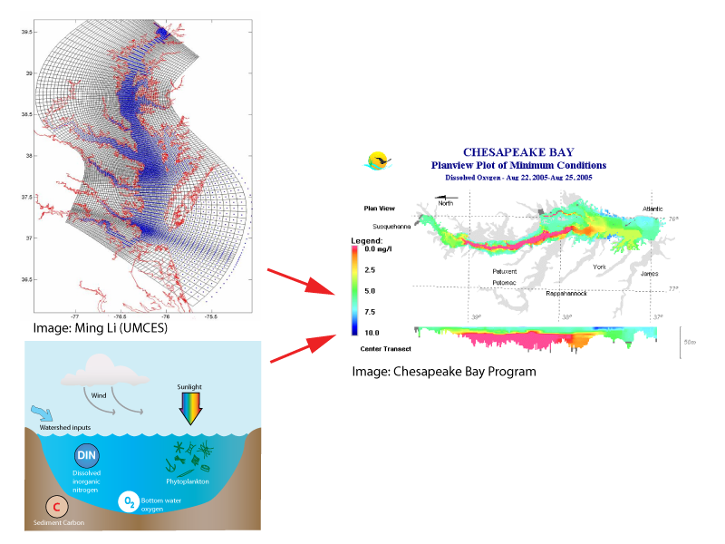
Scientists do field work to study dead zones
Scientists also conduct field experiments to learn about the effects of dead zones on an ecosystem. They collect sediment samples to examine the organisms living inside it and to understand how changes in oxygen affect the release of nutrients and other chemicals from the sediment.


. Black color and very low numbers of organisms indicate anoxic conditions.")
Scientists do laboratory work to study dead zones
Scientists also conduct laboratory experiments to learn about the effects of hypoxia. We use many different instruments to conduct our research and each instrument has a specific purpose.


Scientists monitor ecosystems to study dead zones
Scientists monitor an ecosystem in order to assess how the size of dead zones changes each year. Monitoring also allows scientists to collect data on the causes and effects of dead zones. In the Chesapeake Bay, monitoring stations in Maryland and Virginia waters are visited once or twice each month, and data on oxygen, algae, salinity, and nutrients are collected. In some cases, buoys are deployed to capture short-term changes in oxygen and algae. Using these data, researchers can make plots of oxygen conditions over time to examine how dead zones change over short and long periods.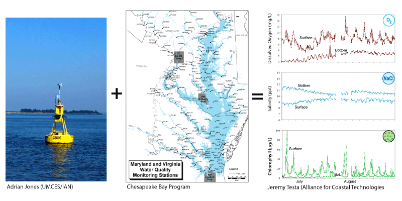
Current Dead Zone Monitoring Programs
Multicultural Students at Sea Together (MAST)
The MAST program or Multicultural Students at Sea Together, is a educational program geared towards promoting diversity in research an exploration in the sciences since 2000. Students explore the Chesapeake Bay while living aboard a 53-foot sailboat. They will study marine science, marine policy, the heritage of African Americans and Native Americans on the water, and learn how to sail the vessel. Twelve students will be selected for the program. Most of the students will have a background in science and be looking toward careers in some aspect of marine or environmental science or policy
Chesapeake Information Management System
The Chesapeake Bay Program (CBP) Information Management System (CIMS) is an initiative to organize large amounts of CBP data across the basin using current distributed Internet technology.
Chesapeake Bay Environmental Observatory
The Chesapeake Bay Environmental Observatory is a program developed collaboratively by computer scientists, ecologists, oceanographers, and environmental engineers to create internet resources on Chesapeake Bay environmental data.
Maryland Department of Natural Resources: Eyes on the Bay
This program collects water and habitat quality data and monitors oxygen and water quality in the shallwo waters of the Chesapeake Bay.
USGS Chesapeake Bay River Input Monitoring Program
The River Input Monitoring Program monitors the concentrations and loads of various nutrients as well as the daily streamflow of rivers in MD, DC, and VA.
The Chesapeake Bay Observing System
This subregional association serves the needs of the Chesapeake Bay, Coastal Bays, and ocean communities by providing observation programs and information.
The National Atmospheric Deposition Program
This precipitation monitoring program monitors geographic and temporal long-term trends through the weekly collection of data on the chemistry of precipitation at various monitoring sites.
Chesapeake Bay Interpretive Buoy System
This system of buoys, developed by the National Oceanic and Atmospheric Administration, serves as a trail guide and observing system. The buoys are set up along the Captain John smith Chesapeake National Historic Trail, and report real-time weather and environmental conditions.