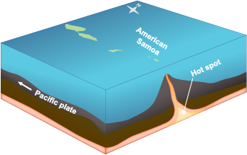
 From the dark depths of the seafloor, volcanic seamounts rise to just below the surface of the Pacific Ocean. Lava flows, fed by hot spots of magma below the earth’s crust, build layer upon layer of rock which make the seamounts taller. When seamounts are high enough to break the surface of the ocean, they become volcanic islands. However, seamounts and volcanic islands are not only moving from the seafloor up, they are also traveling with the earth's crust, which is divided into plates that move with geological activity. The Pacific plate—on which Guam, Hawaii, and Samoa are located—moves westward, but hot spots below the earth’s crust do not move.
 So, after volcanic islands are pushed westward by the movements of the Pacific plate, the stationary hot spot continues to spew lava that forms a new seamount.
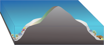
Above the surface of the ocean, volcanic islands are exposed to the destructive forces of wind, rain, and waves. Over time, the rock begins to erode, and the islands become smaller and smaller. All the while, the islands are sinking under their own weight. The heaviness of the volcanic rock depresses the earth’s crust and the islands slip slowly below the surface of the water.
 As the volcanic islands erode and sink, coral reefs form and grow. At first, they form fringing reefs that develop along the shores of volcanic islands. They are called fringing reefs because they border or fringe the island. The coral reefs at Kaloko-HonokÅhau National Historical Park are an example of fringing reefs.
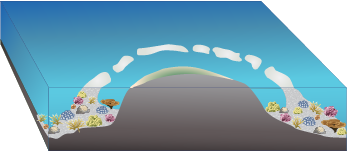
 Over the course of hundreds of thousands of years, the islands continue to shrink through erosion and subsidence. Now, the corals that once fringed the island are further away from the shore, but the reefs are sturdy enough to stand on their own and continue to grow. Thus, barrier reefs are separated from land by a body of water, such as a lagoon or bay. Often, barrier reefs are pierced by channels that allow access to the land beyond.
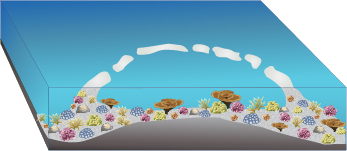
 After millions of years, volcanic islands sink below the ocean and all that can be seen from the surface is a lagoon surrounded by coral reefs. Coral reefs that enclose a lagoon are called atolls. The Pacific Ocean has many atolls that circle peaceful lagoons, such as the Rose Atoll near the National Park of American Samoa.